

In 1944 an engineer named Harold Fisk was tasked with the challenge of illustrating the dense and esoteric report by the U.S. government regarding the nature and origin of the Alluvial Valley of the Lower Mississippi River, which stretches from southern Illinois to southern Louisiana. Understanding the behaviors and fluctuations of natural waterways is something that is complex, even for scientists. But Fisk’s cartographic diagrams make this information more widely accessible by presenting the data gathered from the report in a manner that is aesthetically compelling.
Through applying elements of art and principles of design to chart the changing course of the Mississippi River, Fisk’s maps draw attention to the fluctuating course of nature and enhance scientific discourse. They also serve as a reminder that the phrase “let nature take its course” has profound consequences when reckoning with the state of ongoing environmental crises and human civilization’s role in both their prevention and proliferation.
Turning scientific research into an art form is something artists are adept and familiar with. Essentially the earliest forms of scientific discovery have been achieved through artistic endeavors, such as cave drawings depicting ecological phenomena in prehistoric times (see: “Art Conservators”). Throughout history and across cultural regions, art and science have been intertwined in a manner symbiotic to both disciplines (see: “Rediscovering Astronomy”). The fusion between artwork and scientific analysis has been a key factor for greater understanding and appreciation of the human condition and natural environment, and Fisk’s maps are a good example of the efficacy of this interdisciplinary collaboration.
What Fisk accomplished is a remarkable amalgamation of art, science and history. He referenced the aesthetic and technical work of previous cartographers and art forms documenting the river, such as three historical maps, one of which being Lieutenant John Ross’ influential charting from 1765. Fisk also utilized previous examples of aerial photography that documented the physical nature of the region.
To help viewers visualize the tangible shifts of the Mississippi River, Fisk devised a color palette that would indicate the way the water flow has altered its course over time. Along with differentiating colors, Fisk arranged the annual water flow in chronological layers that overlap one another. The top layer showing measurements taken in 1944 is portrayed via a meandering white line. This layer overlays the river’s course from 1880 represented in serpentine green, which is atop a salmon-pink trajectory from 1820, and finally a light blue flow from 1765. The other colors reflect the river’s course at the time of Indigenous civilization and go all the way back to prehistory.
The Mississippi has been called one of the crookedest rivers in the world due to its natural tendencies to meander far and wide. The river’s majestic features have been an inspiration for many artists, including Mark Twain, who wrote an 1883 memoir called Life on the Mississippi that narrates his experience as a steamboat pilot on the Mississippi River prior to the American Civil War. Regarding the Mississippi, Twain (1883) proclaimed, “one who knows the Mississippi will promptly aver, not aloud but to himself, that ten thousand River Commissions, with all the mines of the world at their back, cannot tame that lawless stream, cannot curb it or confine it, cannot say to it, Go here, or Go there, and make it obey…”
Yet while that might be the case, scientists and engineers have long conspired and made efforts to control the Mississippi River. The river’s sinuous and supple quality, while wondrous and awe-inspiring, has conflicted with advances to modern human settlement. In order to align with the needs of local communities for whom the river is both a life source and a threat, engineers have artificially changed and controlled its flow via the construction of dams, locks, cutoffs and levees. These structures have made it easier for transporting goods and people across great distances, which has bolstered many local economies and also limited the damage from flooding on cities and towns. However, the adverse impact of damming is habitat loss for flora and fauna that also relied on the river for survival (see: O’Connor Toberman, 2022). Another major consequence of human civilization impacting the Mississippi River, is climate change, a condition that has rapidly accelerated due to human related endeavors. In 2022, the Mississippi River faced a historic drought, brought on by a combination of lack of rain and record high temperatures.
Fisk’s maps were designed with the mindset that humans have a significant role in maintaining an equilibrium between nature and civilization. The impetus behind the maps was to attempt to advance the efforts carried out by the United States Army Corps of Engineers to straighten the river. This undertaking had been of utmost importance in the aftermath of massive flooding in 1927. The devastation from the flooding led the United States Congress to direct the U.S. Army Corps of Engineers to channelize the river. Since then, it has been straightened to support navigation and aid in flood prevention via levees. In theory, creating a balance between nature and humankind is a valiant cause laden with good intentions. However, the fallacy of our attempts to control nature’s course are evident through our experiences tinkering with the Mississippi River’s course. In trying to prevent massive flooding with levees, we have increased the flow speed of the river and therefore have made contemporary flooding even more powerful occurrences (Mooney, 2018).
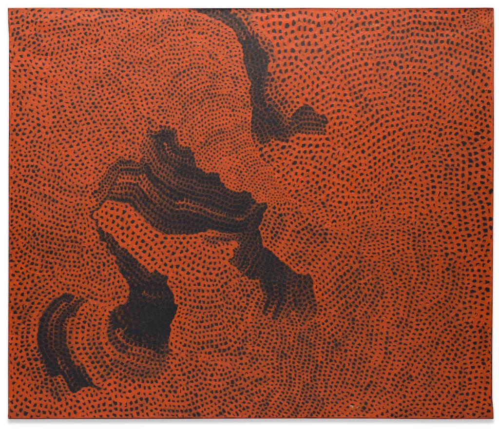
Fisk’s maps were inspired by his desire to control the stability between humans and nature (Christopher, 2015). Artist Yayoi Kusama also addressed her relationship to the Mississippi River through subtle approaches to nature and nurture. Kusama’s orange and black oil painting Mississippi River (1960) symbolizes the rapid current and meandering physicality of the great river through her signature Infinity Net motif of using dots and swirls. The technique Kusama employed is also significant in utilizing repetition as a personal expression in order to seek a sense of calmness and agency over mental duress. The choice to depict the Mississippi River is a tribute to her journey from Japan to the United States, a decision that had epic consequences for her artistic career.
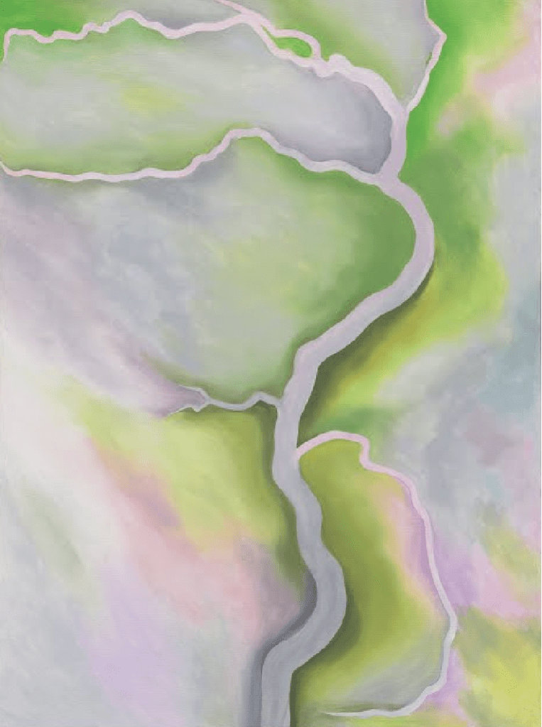
Kusama witnessed the Mississippi River from an aerial vantage point during her first flight to the United States in 1958. The river was also a connection to O’Keeffe, an artist she admired dearly and who was a major impetus for her emigration. O’Keeffe’s late 1950s paintings of meandering rivers depict the untamed force and beauty of the rivers she documented from air travel. The impact of this is twofold, as it signifies the intrinsic ingenuity of nature and the human condition. O’Keeffe and Kusama’s prowess comes from their ability to synthesize such complex and immense landscapes and the many social, cultural and ecological facets they represent into a singular canvas.
Works of art inspired by natural waterways, whether made with a utilitarian purpose like Fisk’s colorful maps, or with a symbolic and expressive sensibility like Kusama and O’Keeffe’s paintings, allude to the vitality of maintaining an equilibrium between humankind and the natural world. The beautiful and poignant themes that artistic representations of nature address are key to fostering our appreciation and advocacy for both our civilization and environment.
References, Notes, Suggested Reading:
Mooney, Chris. “Scientists say the Mississippi is flooding more than it has in 500 years — and we caused it,” Washington Post, 4 April 2018. https://www.washingtonpost.com/news/energy-environment/wp/2018/04/04/the-mississippi-river-hasnt-flooded-this-much-in-500-years/
Morris, Christopher. “Reckoning with ‘The Crookedest River in the World’: The Maps of Harold Norman Fisk,” Southern Quarterly. 52 (Spring 2015). Pps. 30-44.
O’Connor Toberman, Colleen. “The case for and against lock and dam removal,” Friends of the Mississippi River, 21 September 2022. https://fmr.org/updates/land-use-planning/case-and-against-lock-and-dam-removal
Twain, Mark (1883). Life on the Mississippi, Boston: James R. Osgood & Co.
⠀⠀
Discover more from Artfully Learning
Subscribe to get the latest posts sent to your email.

Fantastic artwork.
LikeLiked by 1 person